About the Expedition

On January 21, 2010, scientists from the Coral Reef Ecosystem Division of the NOAA Pacific Islands Fisheries Science Center (CRED/PIFSC), along with visiting scientists from the Hawaii Division of Aquatic Resources, Scripps Institution of Oceanography, San Diego State University, the US Fish and Wildlife Service, and local agencies in American Samoa, departed on a three month expedition to Johnston Atoll, Howland and Baker Islands, American Samoa, Jarvis Island, Palmyra Atoll, and Kingman Reef aboard the NOAA Ship Hi'ialakai. This is the fifth biennial Pacific Reef Assessment and Monitoring Program (Pacific RAMP) expedition to American Samoa and the seventh to the Pacific Remote Island Areas. The expedition is sponsored by NOAA's Coral Reef Conservation Program (CRCP) and is divided into three segment sequentially led by Chief Scientists Benjamin Richards, Rusty Brainard and Jamison Gove.

READ MORE...

Monday, March 1, 2010

Rose Atoll, part 1

By Kerry Grimshaw
Photograph by Jean Kenyon
This afternoon we began our transit to Rose Atoll which is about 240 km (130 nautical miles) to the east of Tutuila. It is often referred to as Rose Island or Motu O Manu (meaning “island of seabirds”) and is the only atoll in the US Territory of American Samoa.

Rose Atoll was first documented in 1819 by Captain Louis de Freycinet who named the isle “Rose” after his wife. It was later visited in 1824 by Otto von Kotzebue and in 1839 by Dr. Charles Pickering, as part of the US exploring expedition, who was likely the first scientist to visit the atoll. Rose Atoll has always been uninhabited except for a brief time in the 1860s when there was an unsuccessful attempt to establish a fishing station and coconut plantation by a German firm. In 1920 a concrete monument was erected on Rose Island by the naval governor of American Samoa to commemorate his visit and allow public access to the atoll. Later in 1941, President Roosevelt made the atoll a naval defense area, but it was never used for that purpose. Rose Atoll became a National Wildlife Refuge on July 5, 1973 and a Marine National Monument on January 6, 2009.

Photograph from noaa.coris.gov
The formation of coral atolls was first described by Charles Darwin during his 5 year voyage through the South Pacific aboard the HMS Beagle from 1831 to 1836. An atoll starts with an oceanic volcano in tropical seas. A fringing coral reef forms on the flanks of the volcanic island and grows upward as the island subsides. The fringing reef separates from the island forming a lagoon as the inner part of the reef begins to subside along with the volcanic island forming a barrier reef. The outer edge of the barrier reef continues to grow and remains near sea level. Eventually the island completely subsides below the ocean surface leaving the barrier reef surrounding a lagoon thus forming a coral atoll.

We are looking forward to the diverse ecological community and habitats that an atoll provides. Rose Atoll will be only the 2nd atoll that we've visited on this mission (the other was Johnston Atoll) and it will be interesting to see how the coral reefs of Rose Atoll differ from those around Tutuila Island.

Saturday, February 27, 2010

Cool Critters of the Reef

text and photographs by Erin Looney

One of the many benefits of conducting coral reef research is the cool critters we encounter almost every day. Whether it is something big, such as a shark, turtle or dolphin, or something small, such as a nudibranch, sea anemone or crinoid, these creatures are all amazing in their own way. Here are a few examples of what we're seeing. All of these organisms were seen in a reef environment between 10 and 20 meters (30 - 60 feet) deep. Enjoy!

Trapezia rufopunctata, Trapezid Crab

Amphiprion perideraion, Pink Anemonefish

Tridacna maxima, Giant Clam

Plerogyra sinuosa, Bubble Coral

Friday, February 26, 2010

A Visitor at Dawn

by Cristi Richards
Flying Fox seen over Cockscomb, Tutuila (photograph by Benjamin Richards)
Preparations for each day of diving generally begin before sunrise, when a quiet, sleepy hush still envelopes the ship. This seemed especially appropriate when yesterday morning, just before sunrise, a silent, graceful silhouette was observed gliding behind the ship. It wasn't a bird but a flying fox or fruit bat.

There are three species of bats living in Samoa, two large fruit-eating bats and a smaller insect-eating bat, which are the only three native mammals in the Samoan Islands. These can seem odd to visitors coming from places where bats are small and generally hard to find or see. In Samoa the sight of a flying fox is a common occurrence. The bat following the ship this morning was one of the fruit-eating varieties which can attain up to a 3 foot wingspan and making it either a Pteropus samoensis (Samoan Flying Fox) or a Pteropus tonganus (Tongan Fruit Bat). While most bats are nocturnal, these bats can be seen throughout the day soaring on thermals or moving between roosting and feeding sites during the dawn and dusk hours.

Both species of bat consume a variety of foods including nectar, pollen, sap and the juice of fruits and leaves. Eating only the juice, the bat will chew on the fruit and press the pulp against the roof of it's mouth creating a pellet of dry pulp known as an ejecta. The ejecta is then spit out to make room for more pulp. This process makes it easy to determine where bats have been feeding and by analyzing the ejecta (commonly found on the hood of your car if you happen to park under a breadfruit tree).

The fruit bats found in Samoa also play an important role in pollination and seed dispersal, increasing the productivity of fruit trees transporting seeds to cleared areas. This aids the natural reforestation process. We are not sure how our flying fox visitor came to be sailing behind the Hi'ialakai instead of feasting in a breadfruit tree, but it was an impressive sight that caught the attention of everyone awake at that hour.

References:
Natural History Guide to American Samoa, 3rd edition, 2009. P. Craig, editor

Thursday, February 25, 2010

Notes from a Coral Reef Microbiologist

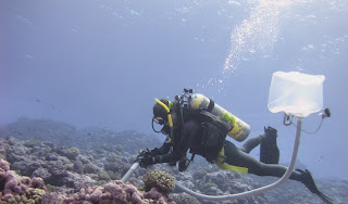
Collecting water samples

by Tracey McDole
Imagine that you are a scientist diving on a coral reef… what types of organisms would you choose to study? Many different life forms probably come to mind, including fish, invertebrates, and of course the corals. However, these are all macroorganisms (“macro” meaning large). In other words, these are organisms that can be seen with the naked eye. What you may not realize, is that an incredible diversity of life also exists at the microscopic scale. In fact, in one drop of seawater there are on average 1,000,000 individual bacterial cells! If that figure isn’t amazing then try one billion viruses per drop! That means that in just a few milliliters of seawater there are more viruses than there are humans on planet earth! Don’t worry, most of them are bacteriophages, viruses that only infect bacteria.

There are, however, some marine viruses that cause disease in reef macroorganisms. Did you know that corals get tumors, a growth anomaly that may be caused by viruses in the family Herpesviridae? Don’t get me wrong, in a healthy reef ecosystem, viruses and microbes play beneficial roles. The coral reef food web is structured so that energy and materials flow from the microbes to macrobes, and back again. Therefore, both viral and bacterial communities are essential components of any healthy reef system.

One of the biggest and most pressing questions that coral reef scientists are currently trying to understand is: How do the combined effects of pollution, overfishing, and climate change result in degraded coral reefs? One way to start is to determine if both groups of organisms (macrobes and microbes) function and interact differently on healthy versus degraded reef systems.

To answer this bigger question, we must start by asking relatively simple questions. How many bacteria and viruses are there on a healthy versus a degraded reef? Are the types of microbes and viruses inhabiting the water column above a healthy reef different from those inhabiting a degraded reef? The first question involves capturing the bacteria and viruses on a filter, staining the filter with a fluorescent-dye that binds to DNA, and finally visualizing the filter with a fluorescent light microscope. The result looks like the night sky! Luckily the microbes and viruses are counted by a computer program.

Microorganisms vs. Macroorganisms
So who’s there? Good guys or bad guys? Answering this question involves a technique called DNA sequencing. DNA from inside the viruses and bacterial cells is purified and the genetic material can then be replicated. When there are enough copies of the DNA, a machine literally reads the base pairs in the DNA sequence. If the DNA sequences match a known sequence in a master database, the microbe or virus that it came from can be identified. Typically, only a portion of the sequences actually “hit” something in the database. This means that the majority of microorganisms and their genes are still waiting to be discovered. But with each water sample we get closer to understanding this complex web of microscopic interactions on the reef.

Wednesday, February 24, 2010

Lilies of the Sea

Crinoid or Sea Lily from American Samoa (photograph by Cristi Richards)
by Benjamin L. Richards

Today the benthic team recovered three Autonomous Reef Monitoring Structures (ARMS) which have been attached to the seafloor in Fagatele Bay National Marine Sanctuary, American Samoa, for the past two years.  This smallest and most remote of all the National Marine Sanctuaries is also the only true tropical reef in the National Marine Sanctuary Program.  Fagatele Bay, on the southwestern coast of the island of Tutuila is a small eroded volcanic crater which provides shelter for a wide variety of organisms that thrive in its protected waters.

After locating the dive site, we slipped over the side of the boat into crystal clear waters and descended to a sea floor covered in coral. We located the three ARMS easily and, after installing a new set of ARMS and a set of calcification plates which will be used to investigate the impacts of ocean acidification, we removed the old ARMS and brought them to the surface.

After returning to the ship, we spent several hours disassembling the ARMS and sorting through all the various creatures who had made it their home.  The biodiversity was amazing. We found a host of crabs, snails, shrimps and a myriad of other tiny and amazing creatures.  We also found our first crinoid.

Crinoids, or sea lilies, are echinoderms (relatives of sea stars and sea urchins) and have lived in the tropical oceans since at least the Ordovician period (~450 million years ago).  Like sea stars and urchins, most crinoids are free swimming and feed by filtering small particles from the passing water with their feathery arms.  Once the food is trapped by a sticky mucus on the tube feet, it is moved towards the mouth at the center of the body.  It has been found that crinoids living in environments with a relatively low abundance of plankton have longer arms than those living in plankton-rich waters.  This is presumably to increase the surface area where food can be trapped.

Finding a such a beautiful and delicate creature in the ARMS was exciting for members of the ARMS team as well as for those who stopped by the lab to glimpse the latest arrivals from the reef.  The diversity of cryptic invertebrates being found is an exciting testimony to how much more there is to learn about reef ecosystems.  As part of the Census of Coral Reef Ecosystems (CReefs) project of the Census of Marine Life, CRED is collaborating with international partners to deploy ARMS on coral reefs around the globe to establish biodiversity baselines and monitor changes over time.

Sunday, February 21, 2010

Talofa Tutuila

Aunu'u and Tutuila (left to right), photo taken by PIBHMC
By Kerry Grimshaw

After nearly a month into our cruise we have begun our work in the US Territory of American Samoa. We are conducting surveys around the island of Tutuila which is the largest and most populated of all the islands in the Territory. Tutuila has a land area of 141.81 km2(54.75 mi2) which is just slightly smaller than Washington D.C. As the third largest island in the Samoan Archipelago (Savaii & 'Upolu in Samoa are 1 & 2 respectively) it is distinctive in the South Pacific for having a large deep natural harbor.

As one of the most protected harbors in the South Pacific, Pago Pago became a point of contention when the United States gained exclusive use in 1872. However, both the British and Germans also had political and trade interests in Pago Pago. After about a decade of mounting tensions and a serendipitous cyclone, the 3countries negotiated in 1889 where Western (Independent) Samoa was ceded to the Germans, eastern Samoa went to the Americans, and the British were happy with German renunciation of Tonga, the Solomon Islands and Niue.

In April of 1900 eastern Samoa was formally annexed by the USA. Traditional rights were protected in exchange for a military base and a coaling station; however, Samoans became US Nationals, but not US citizens. Pago Pago became instrumental during World War II as the center of the Samoan Defense Group, which was the largest of the Pacific Defense Groups. As the war moved north and west, American Samoa became a strategic backwater. In the postwar era, American Samoa's military importance declined and in 1951, the Territory was transferred to the Department of the Interior, under whose jurisdiction it remains.

Until the 1960’s, American Samoa remained almost entirely traditional. After the modernization era, the subtle and restrained US presence was over. In 1977 the first elections were held for democratically elected leadership, replacing the leadership of appointed governors.

Pago Pago Harbor
Tutuila has a reef area of 36.2 km2 (14 mi2) and is home to more than 140 species of corals. Tutuila's waters are protected by the 0.7 km2 (0.3mi2) Fagatele Bay National Marine Sanctuary, as well as by the National Park of American Samoa, which covers the north-central part of the island and approximately 5 km2 (1.9 mi2) of coastline. Tutuila is also unique because of its extensive banks that occur 1-9 km (0.6-6 mi) offshore. On these banks CRED has conducted camera surveys in previous years and documented the presence of corals and numerous species of fish.

We’ll be working in the waters surrounding Tutuila until March 2nd when we begin our transit to Swains Island. For those of you reading from the island of Tutuila you may see us as you are out and about during this time.

Thursday, February 18, 2010

Corals, corals, everywhere ...

by Bernardo Vargas-Angel


High percent coral cover and species diversity; that is what we encountered while working site TUT-09, located on the south-facing shores of Tutuila Island. It was a vibrant tapestry of texture and color; Montipora, Acropora, Pocillopora, Hydnophora, Coscinaraea, Leptastrea, Leptoria, etc; the list of coral genera was endless, and so was the number of individual colonies encrusting on the flat bottom.

The coral working-group of the Benthic Rapid Ecological Assessment (REA) team specializes in gathering data that pertains to the structural demographics of the coral populations. In other words we are interested in acquiring information about the different types of corals present on the reef, their relative abundance, as well as the sizes of the different colonies. Once collected, this information is later summarized and analyzed, and is made available to local, regional, and state resource managers.  Armed with this information, these managers can make informed decisions pertaining to the administration and use of natural resources around the island.

The coral working-group collects the coral demographic data along two belt-transects, 25m in length by 1m width. Today, my dive buddy Erin and I were particularly challenged in getting our work accomplished at survey site TUT-09, not only due to the high numbers of coral colonies growing on the bottom, but also because we had wave and surge action which made it difficult stay focused on one portion of the bottom at a time. Nonetheless, after a long 85 minute dive, Erin and I emerged satisfied with the work we accomplished, and were pleased to have had the opportunity to investigate such a site.