
The Hi'ialakai returned safely to port in Honolulu on Sunday, April 24 at 0800 bringing a very successful completion to HA1001, the 2010 Pacific RAMP expedition to Johnston Atoll, the Phoenix Islands, American Samoa, and the Line Islands. All told, we had the participation of 44 scientists from eight different research institutions and local and regional management organizations. We visited 13 islands, reefs, or banks and were once again amazed by the diversity of life found beneath the waves.
In the days since the ship returned to port we have been offloading equipment and getting everything back to its rightful place, ready for our next expedition to the Northwestern Hawaiian Islands in September of 2010. We want to thank everyone who followed along with our expedition and especially those of you who wrote in with your questions and comments. We hope that we have been able to answer most of them and look forward to hearing from you again on future expeditions.
With that, we will sign off for now. As the Northwestern Hawaiian Islands expedition begins, we will host a new blog and will post the address both here and on the CRED FaceBook page where you can follow-along with all of the most up-to-date information on our program.
About the Expedition
 On January 21, 2010, scientists from the Coral Reef Ecosystem Division of the NOAA Pacific Islands Fisheries Science Center (CRED/PIFSC), along with visiting scientists from the Hawaii Division of Aquatic Resources, Scripps Institution of Oceanography, San Diego State University, the US Fish and Wildlife Service, and local agencies in American Samoa, departed on a three month expedition to Johnston Atoll, Howland and Baker Islands, American Samoa, Jarvis Island, Palmyra Atoll, and Kingman Reef aboard the NOAA Ship Hi'ialakai. This is the fifth biennial Pacific Reef Assessment and Monitoring Program (Pacific RAMP) expedition to American Samoa and the seventh to the Pacific Remote Island Areas. The expedition is sponsored by NOAA's Coral Reef Conservation Program (CRCP) and is divided into three segment sequentially led by Chief Scientists Benjamin Richards, Rusty Brainard and Jamison Gove.
Friday, April 30, 2010
Thursday, April 22, 2010
Perspectives Of Underwater Flight: Towed-Diver Surveys Around The Line Islands
By Jake Asher and Molly Timmers
 |
| Towed-diver Kevin Lino surveys the fish of Jarvis Island |
How can scientists get a better sense of what’s living on the bottom or swimming above coral reefs on an island-wide scale? Detailed surveys examining benthic and fish assemblages at specific sites are one way; however, if you're interested in a fast, effective, and extensive method for assessing and monitoring coral reef health over a large spatial scale, towed-diver surveys are for you.
The towed-diver survey methodology is a unique and integrated data collection method for mesoscale assessment of benthic coral reef habitats. The method utilizes SCUBA divers pulled behind a small boat at depth, covering enormous areas of terrain each day, sometimes surveying close to 18 hectares (18 kilometers x 10 meter survey swath). Multiply that out over a 30-day cruise and you can imagine what the towed-diver team sees!
 |
| Towed-diver forward-facing view; top panel; Typical photograph from the benthic towed-diver. |
What’s on a towed-diver board? Benthic divers have a bottom-mounted camera that collects still photographs of the benthic habitat every 15 seconds, while fish divers have a video camera that records forward-facing video for the duration of the 50-minute survey. Temperature and depth are recorded every 5 seconds throughout the survey (cylinder on the left side). Gauges/timers tell the diver how long the divers have been down for, how deep they are, and sound a 5-minute alarm when each survey segment is completed. Finally, both benthic and fish observations are tallied on the datasheet located on the right-hand side of the board.
Towed-divers
typically fly around the entire forereef perimeter of the smaller
islands, and stagger their surveys along larger ones. In some cases,
divers also survey backreef or lagoon habitats (e.g. at atolls) or
terraces.
Towed-diver observational data can be processed
relatively quickly in order to get a general picture of what the reefs
are comprised of (e.g. hard and soft coral cover, stressed coral, algae,
etc.) and what fishes are present, while the processing of
photographic and video data sets occurs back in the lab in Honolulu.
Given the spatial extent of surveys conducted on this cruise, It would
be impossible to convey everything recorded thus far; however, here are a
few of the benthic highlights from each of the island ecosystems:
Jarvis Island
- Jarvis was largely dominated island-wide by the species of hard coral Montipora aequituberculata.
- The west side has an extensive population of Sinularia (soft coral) found nowhere else around the island, extending ~ 300 meters north-south at the 50 foot survey depth, and covering nearly 100% of the bottom.
- Live, branching Pocillopora and Acropora coral fragments were found along the south-facing shore, suggesting a recent weather/wave event.
- All macroinvertebrates (crown-of-thorns sea stars, sea cucumbers, giant clams, urchins) counts were low. While the reasons for this remain unclear, potential causes include predation pressures or lack of suitable benthic habitat.
 |
| Images obtained from towed-diver surveys of Jarvis Island: Montipora aequituberculata , left panel; Sinularia dominance on the western side of the island, upper right panel; Broken Pocillopora colonies, lower right panel |
Palmyra Atoll
- While towed-diver surveys recorded localized proliferation of a number of hard coral genera, the majority of benthic segments were dominated by a species of Porites along the forereef and western terrace.
- Low levels of bleaching were observed within numerous genera around Palmyra; additional analysis of towed-diver photographs will further explore the extent of coral bleaching around the atoll..
- Visible macroinvertebrates (crown-of-thorns sea stars, sea cucumbers, giant clams, urchins) were nearly absent from our surveys.
 |
| Images obtained from towed-diver surveys of Palmyra Atoll. Partially bleached coral, left panel; forereef, left side; the forereef benthic and fish community, upper right panel; Missing macroinvertebrates, lower right panel |
Kingman Reef
- Hard and soft coral cover varied between habitats, and varied depending upon depth and exposure to wave energy. However, overall hard coral cover for all pooled surveys was nearly identical as all pooled surveys around Palmyra.
- The southeastern backreef continues to harbor the highest concentration of giant clams (Tridacna spp.) of anywhere we surveys around the Pacific.
- The east-side backreef adjacent to the shipwreck showed a dramatic increase in cyanobacteria at 50’ – 60’ since the previous 2008 surveys, along with the presence of a fish aggregation device (FAD) not seen before.
 |
| Images obtained from towed-diver surveys of Kingman Reef. Fish Aggregation Device (FAD) seen from below, left panel; Cyanobacteria bloom near the shipwreck , middle panel; Giant Clams along the southeastern backreef, right panel |
Tuesday, April 20, 2010
Questions related to "Predator Dominated Reefs"
We have received some great questions pertaining to the April 6th blog post entitled "Predator Dominated Reefs". It's always good to know people are intrigued and interested in our research; please feel free to keep the questions coming!
Question 1: How will global warming impact Jarvis Island?
Response by Jason Helyer, Coral Reef Specialist
Response by Jason Helyer, Coral Reef Specialist
This is a great question, but a difficult one to provide a straight forward answer for. Some researchers believe that the cold, nutrient-rich waters that bathe the west side of Jarvis (see blog post “Questions pertaining to the Oceanography of Jarvis Island” regarding upwelling at Jarvis) may provide biological communities at Jarvis protection from climate change associated impacts. In other words, if adjacent ocean temperatures rise, the waters around Jarvis may remain cooler thanks to upwelling associated with the EUC. This cooler water could provide protection to corals at Jarvis from bleaching from rising sea surface temperatures associated with global warming. But this is just a thought shared by some scientists and we really do not know how the oceanographic conditions around Jarvis might change with a changing climate. For example, if the EUC changed as a result of a changing climate, either weakening or deepening, the effects at Jarvis could be substantial as the impact of the current on the oceanographic conditions at Jarvis is a dominant feature structuring the reef community. This uncertainty makes it difficult to answer large questions about how systems might change from global warming and is one of the main reasons why it is important to monitor both biological and physical processes at these remote reefs.
Question 2: In reference to your post that "Jarvis has about 300 times more predatory fish biomass than the entire island of Oahu." What are the factors that reduce the predatory fish volumes in Oahu?
Response to this question as well as the following are by Brian Zgliczynski, Fish Biologist
There are multiple factors that negatively impact populations of predatory fishes. They include fisheries extraction, pollution, and habitat loss. However, fisheries extraction has been shown to have the most deleterious effect on the abundance and biomass of predatory fishes globally. Artisanal, commercial, and recreational fisheries typically target large-bodied commercially-valuable fishes that play an important role in structuring marine ecosystems. As large-bodied species are removed from the system the abundance and biomass of large-bodied predatory species available in the system is reduced.
Question 3: Does illegal fishing occur in the waters around Jarvis and what impact does it have on the trophic pyramid?
Jarvis is one of the most remote and isolated islands under U.S. jurisdiction. This geographic isolation affords Jarvis some protection from anthropogenic disturbances including fisheries. However, this same geographic isolation makes Jarvis potentially vulnerable to illegal fishing activities. As fish populations near inhabited coastal areas are reduced, the threat of commercial fisheries moving offshore to exploit resources at remote and uninhabited islands like Jarvis can become a reality. Fortunately, Jarvis has been designated as a National Marine Monument and is managed and protected under U.S. law out to the 50 nautical mile boundary. This designation provides the necessary legal protection and technologies are being developed to monitor and enforce the Monument boundaries. To date, we have not observed any signs of illegal fishing activities during our biennial reef assessment and monitoring efforts.
Question 4: How does the percentage of predatory biomass at Jarvis compare to Cocos Islands and other areas with high levels of predatory biomass?
Having conducted similar surveys throughout the tropical Pacific including Cocos Island (Costa Rica), the predatory biomass densities observed at Jarvis are among the highest. Additionally, all of the sites where predatory species are abundant display similar inverted trophic pyramids with predatory species accounting for the largest proportion of total fish biomass.
Questions pertaining to "The Oceanography of Jarvis Island"
We received a question by Reille related to the blog post entitled "The Oceanography of Jarvis Island" written by Jamison Gove on 3-April-2010.
Response by Jamison Gove, Oceanographer and Chief Scientist of the current expedition
Great questions Riell! I'll do my best to answer them appropriately, but if you would like more detail on the oceanographic conditions at Jarvis Island, see Gove et al (2006) Temporal variability of current-driven upwelling at Jarvis Island
Question 1: You mention that "few places on the planet have the oceanographic and coral reef environment that is found at Jarvis" could you tell me what other places in the Pacific have both the oceanographic features and the high-productivity coral reef that Jarvis does?
Due to the remote nature of the central equatorial Pacific, I imagine there may be a few islands that have similar ecosystem dynamics as those observed at Jarvis; however, it is the particular location and shape of Jarvis Island which facilitates its oceanographic and biological uniqueness, and when combined with limited human presence over the past half-century, it remains a rarity.
Question 2: I guess something similar happens around the Galapagos and that is a result of the Cromwell Current, as well, but how does the situation there compare to the oceanographic conditions at Jarvis?
They two island ecosystems are comparable as the Equatorial Undercurrent (a.k.a. Cromwell Current) fuels the high productivity at both the Galapagos and Jarvis. That being said, fundamentally different physical oceanographic dynamics occur between the two ecosystems. At the latitude of Jarvis Island, the EUC is flowing incredibly fast for an open ocean current (~1 meter/second) at a depth of 100-150 meters. When this fast moving, subsurface current interacts with Jarvis it results in a cessation of flow, and due to pressure differences, isotherms (lines of equal temperature) are forced vertically upward to the near surface. This island-current interaction driving upwelling is a result of Bernoulli dynamics, which happens to be the very same physical mechanism which gives airplane wings lift.
Due to the upward tilt of the EUC and the thermocline from west to east across the Pacific (see figure below), the EUC is near the surface (0 – 50 meters) at the latitude of the Galapagos Islands. As such, the Galapagos are surrounded by nutrient-rich waters. The productivity at the Galapagos is also enhanced (and therefore my explanation confounded) by natural iron input associated with the geological make-up of the Galapagos Islands, but that’s another question best left for another time.
Question 3: I wonder -- does the size of the island result in differences between one side and the other; does the upwelling affect all sides equally?
The upwelling at Jarvis only occurs to the western side of the island, principally due to the fact that the EUC is an eastward flowing current. Surprisingly, there can be a 1-3 ºC difference between the western side of the island and the eastern side (see figure below). Given that Jarvis is only 4 x 2 kilometers, this is a rather substantial gradient in temperature over a very short distance.
Question 4: Also, could you briefly describe what kind of seasonal variation you see, or variation in El Niño years, and whether you've yet observed organism behavioral adaptations in relation to any variation?
There is definitely seasonal and interannual variability in upwelling at Jarvis. Seasonally, the strongest upwelling at Jarvis occurs during northern hemisphere spring, due to a locally shallow thermocline and shallow and strong EUC. Year to year differences in upwelling are driven by the strength of the trade winds in the western Pacific and their impacts on flow of the EUC; intensified trade winds associated with La Niña conditions favor the shoaling and strengthening of the EUC at Jarvis, and therefore strong upwelling, while a weakening of the trade winds results in a slackening and deepening of the EUC, diminishing or all together shutting down upwelling. Presumably, this variability would impact local fish and benthic coral reef communities; however, we have yet to analyze the data collected during the current El Niño to confirm this statement
Response by Jamison Gove, Oceanographer and Chief Scientist of the current expedition
Question 1: You mention that "few places on the planet have the oceanographic and coral reef environment that is found at Jarvis" could you tell me what other places in the Pacific have both the oceanographic features and the high-productivity coral reef that Jarvis does?
Due to the remote nature of the central equatorial Pacific, I imagine there may be a few islands that have similar ecosystem dynamics as those observed at Jarvis; however, it is the particular location and shape of Jarvis Island which facilitates its oceanographic and biological uniqueness, and when combined with limited human presence over the past half-century, it remains a rarity.
Question 2: I guess something similar happens around the Galapagos and that is a result of the Cromwell Current, as well, but how does the situation there compare to the oceanographic conditions at Jarvis?
They two island ecosystems are comparable as the Equatorial Undercurrent (a.k.a. Cromwell Current) fuels the high productivity at both the Galapagos and Jarvis. That being said, fundamentally different physical oceanographic dynamics occur between the two ecosystems. At the latitude of Jarvis Island, the EUC is flowing incredibly fast for an open ocean current (~1 meter/second) at a depth of 100-150 meters. When this fast moving, subsurface current interacts with Jarvis it results in a cessation of flow, and due to pressure differences, isotherms (lines of equal temperature) are forced vertically upward to the near surface. This island-current interaction driving upwelling is a result of Bernoulli dynamics, which happens to be the very same physical mechanism which gives airplane wings lift.
Due to the upward tilt of the EUC and the thermocline from west to east across the Pacific (see figure below), the EUC is near the surface (0 – 50 meters) at the latitude of the Galapagos Islands. As such, the Galapagos are surrounded by nutrient-rich waters. The productivity at the Galapagos is also enhanced (and therefore my explanation confounded) by natural iron input associated with the geological make-up of the Galapagos Islands, but that’s another question best left for another time.
 |
| Side view of the equatorial Pacific showing the Equatorial Undercurrent flowing east along the thermocline. Note the upward tilt of the EUC from the western to the eastern Pacific. Colors indicate relative temperature, with warmer temperatures shown in red and cooler temperatures in blue. Figure modified from http://www.pmel.noaa.gov/tao/ |
The upwelling at Jarvis only occurs to the western side of the island, principally due to the fact that the EUC is an eastward flowing current. Surprisingly, there can be a 1-3 ºC difference between the western side of the island and the eastern side (see figure below). Given that Jarvis is only 4 x 2 kilometers, this is a rather substantial gradient in temperature over a very short distance.
 |
| Temperature at 25 meters depth around Jarvis obtained from near shore conductivity, temperature, and depth (CTD) casts (locations indicated by triangles). Note the 2.5 degree Celsius difference between the western side and all other sides of the island. Figure taken from Gove et al., 2006. |
There is definitely seasonal and interannual variability in upwelling at Jarvis. Seasonally, the strongest upwelling at Jarvis occurs during northern hemisphere spring, due to a locally shallow thermocline and shallow and strong EUC. Year to year differences in upwelling are driven by the strength of the trade winds in the western Pacific and their impacts on flow of the EUC; intensified trade winds associated with La Niña conditions favor the shoaling and strengthening of the EUC at Jarvis, and therefore strong upwelling, while a weakening of the trade winds results in a slackening and deepening of the EUC, diminishing or all together shutting down upwelling. Presumably, this variability would impact local fish and benthic coral reef communities; however, we have yet to analyze the data collected during the current El Niño to confirm this statement
Monday, April 19, 2010
Autonomous Reef Monitoring Structure (ARMS): Recovery and Processing
By Molly Timmers and Russell Reardon
‘Reef Biodiversity: an Introduction’ posted on the 4th of February introduced coral reef diversity and the Autonomous Reef Monitoring Structure (ARMS). This post will explore the recovery and processing of these platforms.
An ARMS is a tool used to assess the lesser known and cryptic reef organisms. For the past two years, sessile and motile critters have been colonizing the open and closed ARMS layers. One of our missions on this cruise has been to recover all the previously deployed ARMS for immediate shipboard and subsequent land-based processing.
We remove the ARMS from the benthos by attaching a milk crate lined with an 80 micron mesh over the center stack of plates comprising the structure. A buoyed rope is then attached to the latching straps on the crate, and the whole unit is pulled to the surface. The milk crate ensures that any recruited organisms within the ARMS will not fall out during transport. Once on the surface and in the small boat, the milk crate encapsulated ARMS is placed within seawater-filled bins and transported back to the Hi‘ialakai.
Back on the ship, the ARMS is disassembled within a tub of seawater. The milk crate is detached, and each layer (plate) is removed individually. The top and bottom of each plate is photographed to document the sessile organisms. Once photographed, a paint brush is used to lightly sweep any motile organisms off the plates and into a bucket of seawater. The plates are then placed in ethanol to preserve the DNA for future molecular processing.
Once every layer has been photographed, brushed, and preserved, all of the buckets of seawater used during the processing are sieved into the following bins: 5 mm, 2 mm, 500 ?m, and 100 ?m. The contents from the 2 mm, 500 ?m, and 100 ?m sieves are bulked and placed immediately into ethanol. Selected critters found within the 5 mm sieve are photographed, identified, and preserved individually while the remaining 5 mm organisms are bulked and placed in ethanol.
The final task is to scrape the sessile organisms from the all the plates. The scrapings are bulked and preserved. In this manner, we are able to remove, preserve, and store all of the sessile and motile organisms that have recruited to the ARMS.
When we return to land, the contents will be sent to our partners at the Smithsonian, the Florida Museum of Natural History, and the Hawaiian Institute for Marine Biology who will begin the molecular processing and taxonomic archiving. Genetic sequencing will provide a relative index of diversity for each of our survey sites. We will then be able to compare these indices among and between sites, islands, and regions. Ultimately, this process may allow us to detect and monitor changes in cryptic diversity in an effort to understand ecosystem shifts overtime.
‘Reef Biodiversity: an Introduction’ posted on the 4th of February introduced coral reef diversity and the Autonomous Reef Monitoring Structure (ARMS). This post will explore the recovery and processing of these platforms.
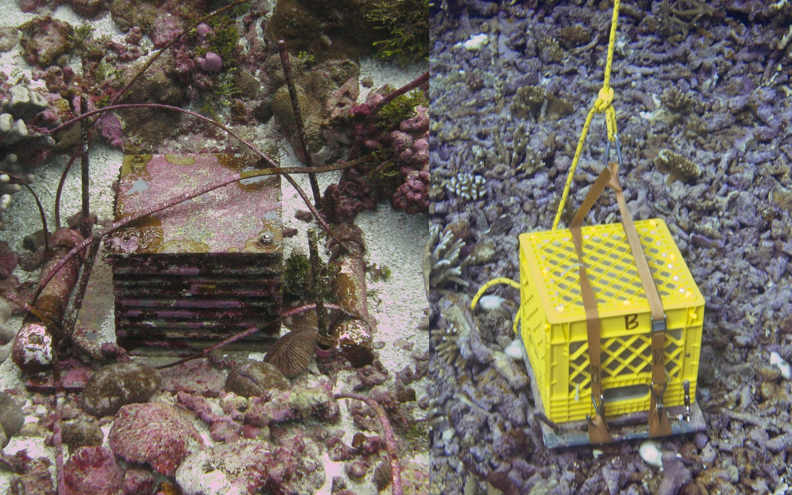 |
| ARMS awaiting removal on left, encapsulated ARMS on right |
We remove the ARMS from the benthos by attaching a milk crate lined with an 80 micron mesh over the center stack of plates comprising the structure. A buoyed rope is then attached to the latching straps on the crate, and the whole unit is pulled to the surface. The milk crate ensures that any recruited organisms within the ARMS will not fall out during transport. Once on the surface and in the small boat, the milk crate encapsulated ARMS is placed within seawater-filled bins and transported back to the Hi‘ialakai.
Back on the ship, the ARMS is disassembled within a tub of seawater. The milk crate is detached, and each layer (plate) is removed individually. The top and bottom of each plate is photographed to document the sessile organisms. Once photographed, a paint brush is used to lightly sweep any motile organisms off the plates and into a bucket of seawater. The plates are then placed in ethanol to preserve the DNA for future molecular processing.
 |
| An example of a plate photograph |
The final task is to scrape the sessile organisms from the all the plates. The scrapings are bulked and preserved. In this manner, we are able to remove, preserve, and store all of the sessile and motile organisms that have recruited to the ARMS.
 |
| ARMS processing in action. Upper left, disassembling; lower right, brushing; middle, photography; lower right, sieving; upper right, scraping. |
 |
| Examples of invertebrates found within the ARMS |
Saturday, April 17, 2010
Kingman Reef
By Kerry Grimshaw
We have arrived last stop for this expedition, Kingman Reef. Located nearly halfway between American Samoa and Hawaii (1700 km/1056 mi), Kingman is the northernmost reef of the Line Islands. First discovered by Captain Edmund Fanning in 1798 it was later described in 1953 by the island’s namesake Captain W.E. Kingman. Other pre-twentieth century names for Kingman include Danger Reef, Cladew Reef, Maria Shoal and Crane Shoal. In 1856 Kingman Reef under the name “Danger Reef” was claimed by the US as part of the Guano Islands Act. Kingman was later formally annexed 1922 as an unincorporated U.S. possession of the United States.
The lagoon at Kingman Reef was used as a halfway stop for Pan American Airways flying boats in 1937 and 1938 for flights between Hawai’i, American Samoa, and New Zealand. To facilitate this overnight stop a supply ship was stationed at Kingman to provide fuel, lodging and meals. After a fatal explosion shortly after take off from Pago Pago in January 1938, Pan Am stopped flights to New Zealand via Kingman Reef and Pago Pago. A new route was later established through Canton Island and New Caledonia. In 1941 the US Navy assumed control of Kingman and maintained its jurisdiction until 2000. Kingman Reef was established as a National Wildlife Refuge on January 18, 2001. On January 6, 2009 Kingman Reef was designated as part of the Pacific Remote Islands Marine National Monument.
Kingman Reef is an uninhabited, triangular shaped reef that is mostly submerged. A small, single strip of “dry land” composed of mainly of dead and dried coral skeletons, is located on the eastern rim of the reef. With the highest point of land at approximately 1 meter, the island is often awash during high tide and is inhospitable for most organisms. Despite the harsh surface conditions Kingman Reef supports a vast variety of marine life below. Approximately 130 species of corals are known at Kingman and giant clams are abundant in shallow waters. Predators dominate the waters at Kingman similarly to most of the uninhabited islands we visit.
 |
| Kingman Reef from above |
 |
| The only emergent land at Kingman; a narrow strip of coral rubble and coarse sand |
 |
| A cluster of Giant Clams (Tridacna maxima ) at Kingman Reef |
Kingman Reef is an uninhabited, triangular shaped reef that is mostly submerged. A small, single strip of “dry land” composed of mainly of dead and dried coral skeletons, is located on the eastern rim of the reef. With the highest point of land at approximately 1 meter, the island is often awash during high tide and is inhospitable for most organisms. Despite the harsh surface conditions Kingman Reef supports a vast variety of marine life below. Approximately 130 species of corals are known at Kingman and giant clams are abundant in shallow waters. Predators dominate the waters at Kingman similarly to most of the uninhabited islands we visit.
 |
| Oceanographer Chip Young surveys the reef at Kingman |
We’ll be here for the next 6 days conducting our standard suite of work before beginning the transit home.
Thursday, April 15, 2010
Palmyra undwater
We've spent the past 7 days conducting surveys and retrieving/deploying oceanographic instruments in the waters around Palmyra Atoll. Here are a few photos from below the water's surface:
 The soft coral, Sarcophyton sp.
 Scientist Nichole Price conducts a Line
Point Intercept survey.
 Oceanographer Jamison
Gove installs an Acoustic Doppler
Oceanographer Jamison
Gove installs an Acoustic Doppler
Profiler and subsurface
temperature recorders.
 Layers and layers of corals!
  Sea slug (Elysia ornata).
  The camouflage grouper (Epinephelus polyphekadion).
 Oceanographers Chip Young and Danny Merritt
retrieve the Remote Automatic Sampler.
 Threadfin butterflyfish (Chaetodon auriga) swimming
over a carpet of invasive corallimorphs (Rhodactis howesii).
 An Acropora sp. thicket in the coral gardens of Palmyra.
 A school of convict tangs (Acanthurus triostegus) swoop in
to mow the algal lawns on this section of reef.
 An interesting and unusual formation of Acropora sp.
 Acropora sp. tables found on the western terrace.
 A blacktip reef shark (Carcharhinus melanopterus) cruising near the coral gardens.
 A curious Twin-spot Snapper (Lutjanus bohar) comes in for a
closer look
A curious Twin-spot Snapper (Lutjanus bohar) comes in for a
closer look
while oceanographer Jamison Gove installs a subsurface temperature recorder in the background.
 A Napoleon Wrass (Cheilinus undulatus) swims by.
Here are a few of the critters we have found within the Autonomous Reef Monitoring Structures around Palmyra:
 A swimmer crab (family Portunidae).
  A spaghetti worm (family Terebellidae).
 A money cowrie (Cyprae moneta).
 A fire worm (family Amphimonidae)
 A snapping shrimp (Alpheus sp.)
We have seen many interesting animals,both large and small, here at Palmyra Atoll. While always interesting it is time for us to continue on to the final destination of this expedition: Kingman Reef.
Subscribe to:
Posts (Atom)
.jpg)